TasRep Guidelines
Reporting Your Position
You must contact Tas Maritime Radio at least once each day, more frequently if you are out of sight of land, possibly following a regular sked, or at a pre-arranged time. Call as you depart and let us know when you intend filing position reports and try to adhere to those times.
At the end of your journey it is especially important that you close your Transit Log by advising that you have arrived at your destination, or when leaving the coverage area, that you are closing with Tas Maritime Radio and now wish to be handed over to an adjacent coast station. (See coverage areas and adjacent coast stations below.)
VHF Coverage
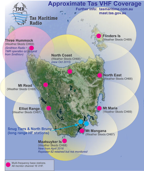
Tas Maritime Radio's predicted VHF coverage is shown in this diagram along with those of adjacent VHF stations. The TMR areas show that Tas Maritime listens on VHF channel 16 and they also show the sked channels used in those areas.
Tas Maritime monitors channel 16 for emergency calls 24 hours each day, and for general traffic between 0700 and 1900 each day.
Outside these coverage areas you can still contact Tas Maritime Radio (if your vessel has the appropriate equipment) using HF radio, satphone or email (see below).
HF Coverage
HF coverage is always affected by atmospheric conditions however Tas Maritime Radio routinely works vessels in New Zealand and the South Pacific. Adverse conditions can make communication on HF very difficult indeed and you should therefore carefully consider which band is best to use at any given time. By day 4MHz should work well up to 300km, 6MHz up to 750km, 8MHz up to about 2000km. All have greater range at night. If you are having trouble with a particular frequency band, try the next higher one.
Tas Maritime Radio monitors HF calling/distress frequencies: 4125, 6215, 8291 kHz between 0700 and 1900 each day.
Note that if you are testing your HF you will have difficulty receiving if your vessel is in a marina. For best results you need to be in open water.
If you have email on board during your voyage (via satellite) you can communicate with Tas Maritime by sending an email to ops@tasmaritime.au - It can be easier to provide positions and other details if there's a lot of radio interference. The same goes for satphone - call +61 3 6231 2276. In an emergency situation email should be the last resort due to the time lag in delivery.
What Should You Tell Us?
•
Latitude & Longitude (if you have GPS) stating the format you are using (
Click here
to see why);
•
Distance & bearing from well-known landmark eg 5nm SE of Tasman Island;
•
POB (in case it has changed from your initial Transit Form);
•
ETA for next port;
•
Whether you are overnighting somewhere or stopping over for a few days;
•
Any other relevant information eg course & speed.
Completing the Online Form
The form is designed to aid SAR authorities in the event of a distress situation.
•
Complete every field that is relevant and submit the form.
•
Take note of instructions on the form. Fields marked with an asterisk (*) are required.
•
Underlined words
- hover your mouse over these words to get information about the field.
•
The number of available colours is restricted on the form ñ select the closest (eg red
instead of crimson).
•
When you first submit your form the program will check it and it will then reappear, giving you a chance to correct any errors.
•
The second time you submit it, it goes to the Tas Maritime database and you will no longer be able
to change any details.
•
Note you have to submit the page twice.
Note that you need to have recent version of Firefox or Chrome browsers for all the features on this form to work, and if you are using Internet Explorer, it needs to be at least version 10. If you are using an older browser, please make sure you enter details exactly as shown on the form.